Photo:
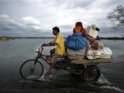
Char Kazul is a riverine island comprised of four villages, located between the Bura Gaurango and Tetulia rivers in Bangladesh. During monsoon season, the Bura Gaurango River can swell up to 10km wide, making it difficult for residents to reach the mainland for trade and services.
Climate change models predict more frequent cyclones over a longer season, which will increase the occurrence of storm surges, riverbank erosion, salinity intrusion, abnormal high tides, rough sea weather conditions, and erratic rainfall. Changing weather patterns and social pressures have resulted in widespread degradation of arable land, as well as negative impacts on local flora and fauna.
This project (July 2011-December 2012) improved community-based adaptive capacity by piloting sustainable agriculture practices and promoting land conservation. Demonstration and promotion of saline-tolerant rice varieties, alternative crops, and crop intensification sought to improve agriculture production whilst reducing the effect of climate related risks. Additionally, the project increased the capacity for coping with natural weather hazards by rehabilitating mangrove forests and renovating house and boat structures.
- Community
- National Governments
- Non-Governmental Organizations
Farmers; Coastal Communities; Riverine Communities
- Center for Natural Resource Studies (CNRS)
- Bangladesh Rice and Research Institute (BRRI)
- Chevron - Bangladesh
- United Nations Development Programme (UNDP)
- Global Environment Facility (GEF)
- Government of Bangladesh
- UK Department for International Development (DFID)
Char Kazal is a riverine island bounded by the BuraGaurango and Tetulia rivers with a population of approximately 21,100 people. During monsoons, the BuraGaurango swells to 7 to 10 kilometres, making it difficult to reach the mainland. Limited access to resources on the mainland such as emergency medical services and market centers increases the vulnerability of the Char Kazal community to the negative effects of extreme weather. The community is almost entirely dependent on natural resources for their livelihood, engaging in agriculture, wage-labor and fishing as their primary occupations.
Over the last 10 to 15 years, soil erosion and degradation has decreased the amount of arable land on the island, making it more difficult to grow sufficient crops. Sand carpeting and salinity intrusion are the main causes of soil degradation and are exacerbated by recent climate shifts. Poor crop yields have forced many community members to change occupations that are further away from the village and are not always as profitable. A recent census in the area showed that approximately 60 percent of households do not have access to land for farming and are constantly at threat from food insecurity.
Climate change is projected to exacerbate these effects, bringing with it an increase in temperatures, reduced and erratic rainfall, heat waves, and more frequent rainstorms. The changing climate conditions will likely reduce the availability and productivity of agricultural land as well as disrupt aquaculture practices.
This project aims to reduce these stresses and enhance resilience through a focus on adaptive agriculture and natural resource management. Pilot demonstrations will assess the value of saline-tolerant rice varieties and alternative crops, crab fattening and duck breeding, and crop intensification methods. Both the local ecosystem and community infrastructures will be protected from extreme weather events through the rehabilitation of mangrove forests, and the establishment of ‘live fences’ to protect homesteads and cattle during cyclones. Building on the communities’ existing knowledge, the project also plans to improve organizational and technical capacity skills that will be invaluable in continued development initiatives.
Outcome 1: Increased capacity for adaptive farming in face of climate change risks
Complete multiple demonstration trials for adaptive agriculture, including for: saline-tolerant rice varieties (Output 1.1); alternative crops (i.e. watermelon, maize) in sand-carpeted areas (Output 1.2); soil-salinity minimization techniques (Output 1.3); farmland crop intensification (Output 1.4); and crab fattening (Output 1.5) and duck-rearing in inundated farmlands (Output 1.6).
Outcome 2: Increased capacity for coping with natural hazards
Complete demonstration plantation of mangroves to minimize effects of storm surges, high-tides, etc. (Output 2.1) and demonstration plantation to create live fence with coconut trees to protect homesteads from cyclones (Output 2.2). Complete demonstration renovations of houses (Output 2.3) and country-boats (Output 2.4) to make them cyclone-resilient. Construct killah (raised platforms) to protect cattle during cyclone and storm surge (Output 2.5).
CNRS personnel will facilitate, and will involve CMC to conduct the monitoring and evaluation activities. For the Vulnerability Reduction Assessment all indicators (assessed in the Initial VRA analysis) will be monitored and measured again in second VRA meeting planned to be conducted during the implementation phase (halfway) and again upon completion of the project implementation. Depending on funds availability, a fourth consultation may be conducted a year after the completion of the project implementation.
- CNRSM. Anisul IslamExecutive Director (Acting)
- BRRIMd. Shamsher AliCSO and Head, Biotechnology Division
- UNDPCBA Project Management Unit
